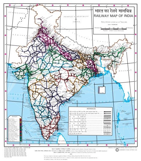
Indian Railway Route Map PDF is a high-quality, official map that shows the complete Indian Railways network for the year 2025. It details every part of the system, including major railway zones, division boundaries, capital cities, junction stations, and the different types of tracks (metre gauge and broad gauge). It also shows routes that cross international borders.
This map confirms the latest updates to the network, making it a very useful resource for travelers, students, and researchers.
Major Railway Zones
The map uses different colors and lines to clearly show the various railway zones across India. You can see the specific areas and headquarters for:
- Central & Western: Mumbai (Central and Western Railways), Jabalpur (West Central), Jaipur (North Western), and the coastal Konkan Railway.
- North: Delhi (Northern), Gorakhpur (North Eastern), Prayagraj (North Central).
- South: Chennai (Southern), Secunderabad (South Central), Hubballi (South Western).
- East: Kolkata (Eastern and South Eastern), Guwahati (North East Frontier), Bilaspur (South East Central), Bhubaneswar (East Coast).
Complete Coverage of India
The PDF displays railway connections across the entire country:
- North India: Connects cities like New Delhi, Chandigarh, Jammu, Amritsar, Lucknow, and Varanasi.
- East India: Covers Howrah, Patna, Bhubaneswar, Guwahati, and Siliguri.
- West India: Shows routes through Mumbai, Ahmedabad, Vadodara, Surat, and Jaipur.
- South India: Includes Chennai, Bengaluru, Hyderabad, Kochi, and Trivandrum.
Who Should Use This Map?
This document is essential for:
- Students: Especially those preparing for UPSC, SSC, and Railway entrance exams.
- Travelers: For planning long-distance journeys.
- Professionals: Teachers, transport researchers, and logistics planners who need to understand connectivity across India.