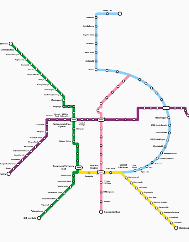
Bangalore Metro Map pdf free download here, Bangalore Metro Map (PDF Download, Latest Routes & Stations Guide). The Bangalore Metro Map PDF is an essential resource for navigating the rapidly expanding metro network in Bengaluru. Designed for commuters, tourists, and daily travelers, the map provides a clear visual of all operational lines, interchange stations, and key stops across the city. Whether planning a daily commute or exploring new areas, the latest Bangalore metro map simplifies travel with accurate route information and station connectivity.
The latest Bangalore Metro map highlights two major corridors—Purple Line and Green Line—along with newly extended routes. Having a downloadable PDF version ensures offline access, making it especially useful in areas with limited connectivity.
Overview of Bangalore Metro
The Namma Metro is operated by the Bangalore Metro Rail Corporation Limited. It is one of India’s most efficient urban transit systems, connecting major residential, commercial, and IT hubs across Bengaluru.
Key Highlights:
- Fully operational Purple Line (East–West corridor)
- Fully operational Green Line (North–South corridor)
- Modern stations with smart card and QR ticket systems
- Affordable and time-saving alternative to road transport
Bangalore Metro Map PDF (What It Includes)
The Bangalore Metro Map PDF free download typically includes:
- Complete route layout of all metro lines
- Clearly marked interchange stations
- Terminal stations and extensions
- Major landmarks and nearby locations
- Color-coded lines for easy navigation
This makes it ideal for:
- Daily commuters
- Tourists visiting Bengaluru
- Students and office workers
Bangalore Metro Lines Explained
Purple Line (East–West Corridor)
Connects Whitefield (Kadugodi) to Challaghatta, covering major areas like Indiranagar and MG Road.
Green Line (North–South Corridor)
Runs from Nagashettihalli to Silk Institute, passing through key zones like Yeshwanthpur and Majestic.
Interchange Station
- Majestic (Nadaprabhu Kempegowda Station) – The central hub where Purple and Green lines intersect.
Bangalore Metro Stations List
Purple Line Stations:
- Whitefield (Kadugodi)
- Hopefarm Channasandra
- KR Puram
- Baiyappanahalli
- Indiranagar
- Halasuru
- Trinity
- MG Road
- Cubbon Park
- Vidhana Soudha
- Majestic
- Vijayanagar
- Attiguppe
- Kengeri
- Challaghatta
Green Line Stations:
- Nagashettihalli
- Yeshwanthpur
- Mahalakshmi
- Rajajinagar
- Majestic
- Chickpete
- KR Market
- Lalbagh
- Jayanagar
- Banashankari
- Silk Institute
Benefits of Using the Bangalore Metro Map
Using the Bangalore metro map latest version offers several advantages:
- Efficient route planning: Quickly identify shortest paths
- Time-saving travel: Avoid traffic congestion
- Easy navigation: Clear station names and interchanges
- Offline usability: PDF format works without internet
- Better trip planning: Helps estimate travel time and connections
Things to Keep in Mind While Using Bangalore Metro
- Peak hours: Expect heavy crowds during morning and evening office hours
- Smart cards: Using a metro smart card saves time and offers fare discounts
- Last train timings: Check timings before planning late-night travel
- Security checks: Allow extra time for entry screening at stations
- Interchange planning: Majestic station can be crowded; plan accordingly
- Luggage rules: Large baggage may be restricted
Practical Uses of the Bangalore Metro Map PDF
- Planning daily office commute routes
- Identifying nearest metro stations
- Navigating unfamiliar parts of the city
- Creating travel itineraries for visitors
- Reducing dependency on private transport
final word
The Bangalore Metro Map PDF is more than just a route guide—it is a practical tool for efficient urban travel. With clearly marked lines, stations, and interchanges, it enables smooth navigation across Bengaluru. As the metro network continues to expand, keeping the latest version of the map ensures accurate and stress-free commuting.
Frequently Asked Questions (FAQs)
1. Where can I download the Bangalore Metro Map PDF?
The map can be downloaded from the official BMRCL website or trusted transport resources offering the latest metro updates.
2. What are the main metro lines in Bangalore?
The two primary lines are the Purple Line (East–West) and Green Line (North–South).
3. Which is the busiest metro station in Bangalore?
Majestic (Kempegowda Station) is the busiest as it connects both metro lines.
4. Is Bangalore Metro map available offline?
Yes, downloading the PDF allows offline access anytime.
5. How many stations are there in Bangalore Metro?
The number is increasing with expansions, but currently includes dozens of stations across two major lines.